


Corduroy Roads in the James River: What Are We Looking At?

Sunday, June 23, 2019, was an exceptionally beautiful day—windy and clear—ideal weather for floating on the James River. Curtis Daily grabbed his red canoe and his dog, Liberty, and headed to the Madison Heights boat ramp, across the river from downtown Lynchburg.
Drifting along, about two hundred feet downriver from the tip of Percival’s Island on the Amherst side, something unusual caught his eye. Looking down through the shallow water, he spotted several uniformly arranged logs, each about eight feet long, side by side on the sandy bottom.
In the weeks following his discovery, Daily made contact with Thomas Klatka, an archaeologist with the Virginia Department of Historic Resources, and escorted him to the site. Klatka’s description of the underwater structure, later forwarded to Daily in an email, is as follows:
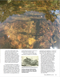
2019 – This archaeological site is a section of a corduroy road discovered under the waters of the James River by Curtis L. Daily. It is located in a shallow area of the river about 2 feet deep at the time of documentation. The exposed section of the road measures 10 feet long by 8 feet wide and appears to be a series of timbers about 4 inches in diameter affixed to two lines of underlying timbers that measure about 6 inches in diameter. The underlying timbers are aligned end-to-end in two parallel lines about eight feet apart that support the series of overlying timbers. The 10-feet-long section of exposed road trends at a compass bearing of 65°–245° to connect the northern bank of the James River to the northern bank of Percival’s Island in the river.
Some of the overlying timbers in the exposed section of the corduroy road are not in place. This suggests two possible forms of the corduroy road. It may have consisted of an unbroken series of overlying timbers to form a timbered road surface across the width of the river. Water erosion may have dislodged and removed some of the timbers after the road fell out of use. Alternatively, the overlying timbers may have been laid with gaps that were infilled with sediment and small river-rocks to form a timber and rock road surface.
I encountered Daily one Sunday a few weeks later when I was standing at the boat landing flying my drone over the city. He asked if I did underwater photography and told me what he had found. I could not resist the offer, and, with a waterproof camera bag and borrowed GoPro, I accompanied him on several adventures back to the river to document the corduroy road.
^ Top
Previous page: My Illegal Bootleg Radio Station: The WKKD Story
Next page: Horse Ford to Glass Memorial: The Lynches Establish and Hold a Crossing on the Fluvanna River
Site Map